Machu Picchu (Old Mountain)
We were really there! The work that went into building Machu Picchu and the surrounding terrace farms and test farms is phenomenal. Remember that like the iceberg, we are only seeing the surface level. A lot of work went into building foundations to support everything we see, otherwise this stuff would have slid down the mountain side long ago. So if nothing else this place is a monument to human ingenuity, effort and engineering.
I don’t think any individual building or piece of ruin at the site was particularly awesome by itself. It’s the overall context, and the survival of so much that makes this such an outstanding place to be. And certainly being draped amongst the mountain tops is pretty cool. There are many theories as to why Machu Picchu was built and why it was abandoned after less than 100 years of use.
Yesterday we looked down from the Gate of the Sun at Machu Picchu, as you can see….we were feeling somewhat bedraggled….after our up, up, up hike.
Today we were clearly feeling young and sprightly! Ready to see this massive ruin.
You start above the ruin. Pavel took pictures of each of the tour participants, and we all posed for a group shot.
We then hiked up the hill to look at the western slope of the complex. The big hill behind the ruins is called Wayna Picchu (Young Mountain)…more about that hill later.
As you gaze off into the east, you are looking at the ‘Cloud Forest,’ the Amazon jungle lays slightly beyond these hills. The cloud forest is simply the rainforest with hills. By looking at the serrated mountain tops, you can begin to see how the Inca’s might notice patterns relative to the path of the sun. Obviously this would also require some patience and tenacity as they tried to understand & map the limits of the solar march from left to right and then back again, as the sun played amongst the mountain peak points.
Entering Machu Picchu
We then walked down from this overlook and through the Inka Punkö, or doorway to the city. During Inca times this was the only entrance. If you look closely you can see a porthole above the doorway and on the sides of the doorframe there were cutouts (not shown) to secure the door.
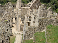
Here are two photo’s that show differences in stone quality. Lynn is standing by the walls of one home, that are nice, but pale in quality to the picture on the right. Which Fredy said was probably the home for the Inca Chief’s prime minister of the site/region.
Next are two views of the temple of the sun. The first from above, and the second down lower from the side. The window in this lower view, is different from the one on top. This window cast a shadow on the natural stone in the temple to show the Spring Equinox. So the Inca’s would know when to start planting.
There is another temple below the Sun Temple. This is where the sacred mummies were kept. The mummies were brought out to participate in major holidays and events. These photographs show several things moving from left to right. Fredy was giving us an explanation of this temple. The light and shade diagonal lines represent the after life and human life today. The staircase has three carved steps and in this instance a platform. The three steps is significant. The first step represents the ‘snake’ and the afterlife. The second the ‘puma’ and human life, and the third or highest step, the condor – the celestial/spiritual plane of the gods.
Wayna Picchu (Young Mountain) Climb
We had an opportunity to climb Wayna Picchu, which is pictured above at the back of the Machu Picchu ruins. For some reason, I was the only nut case to try this. Picture the ‘oh my god, 55 steps x some big number of steps…..and that was my hike. It was not only up, up, up…it was a very steep up/UP/UP! Here is a picture for 2/3 the way up the hill, the path (if one could call such a thing a path) is off to the right.
My reward was a picture of me standing on a rock with Machu Picchu in the background. So I got to see the whole complex from the left and the right. Cool eh? ;o)
Various Buildings & Monumnets at Machu Picchu
Here are a few pictures of the many wonderful buildings on the site. This one is the astronomical observatory, the Intihuatana and its carved stone, the corners of which are aligned with the four cardinal points (East, South, West & North). This may be the only surviving stone like this, the Spaniards destroyed the others, as they eliminated Inca icons and symbols.
The Temple of the Condor – with the condor’s head on the ground and his wings those massive boulders angling from side-to-side.
And finally the great stone, with both a group shot and another picture that shows you how the top of this stone was made to fit the natural slope of a mountain in the background. The parallax, points again used for calculating changes in the sun and the stars.
We slept soundly in the beautiful Pueblo Hotel that night. Here is pic of me, working on the Blog.
The next day (our last) we stopped by a local establishment to sample the ‘corn liquor.’ Fredy was showing us how to make an appropriate offer to the gods and to mother earth and to to play the game Sapo (Frog). Jane, Lynn, Bob & Martin were on one team. Bob kicked butt.
And that was our trip. It was a wonderful experience! Lynn and I enjoyed the group, learned much from our guides and would truly love to go back to Peru at some point again in the future.
Thank you for sharing our trip. We wish you all the best.
Lynn and Michael
Monday, September 17, 2007
Sunday, September 16, 2007
The final walk to Machu Picchu - Day 7
On the ‘Real’ Road to Machu Picchu.
This was the day we had been waiting for. We drove to Ollantaytambo (9,200 feet 2,800 meters vs. Denver at 5,600 feet), where we boarded the train and rode to kilometer 104 where we exited at Chachabamba (elevation 6,300’/1,900m).
The train runs next to the Urubamba which is pretty narrow all of the way, but there were some major white water rapids, off to our side, given the elevation drop. One stretch of rapids seemed to run for 3 or more kilometers.
There is also a major glacier ‘Veronica’ resting far above the train tracks. Chachabamba has a bridge over the river, a train stop, a small village ruin by the same name.
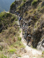
We did the one-day hike up the Inca Trail, rather than the 4-day back packing trip. It was less strenuous…but there was still quite a bit of up, up, up. The elevation
Fredy and Pavel pretty much told everyone in our group to go at their own pace, and don’t fret over what someone else is doing. Along the way we passed many beautiful flowers and the scenery looking off into the distance was outstanding.
We took a short rest at a waterfall. I jumped underneath the spray, it was quite cool, no it was quite cold, but it felt good.
The area we were walking through is known as the "Cloud Forest." This is the zone between the Rain Forest and the high mountain plateaus.
Our goal for lunch was to reach the Wiñyawayna ruin, which means ‘forever young.’ It is named after an orchid that blooms several times a year on the mountain. The Wiñyawayna Ruins can be seen off in the distance.
We plopped ourselves down for lunch on one of the terraces.
We looked down where the engineers and astronomers lived/worked on this site.
We had seen several places before where a set of stones extends out from the terrace walls. Very much like a modern day staircase. I finally had an opportunity to walk up a few sets. It might be somewhat difficult to see, but the width of the terraces is narrow, these terraces were only used for test purposes.
If you look closely you can see the trail we hiked through one of the building windows at Wiñyawayna. Fredy told the group we were going to experience an "Oh my god!" moment on our hike. I'm still not sure if he was referring to a stair case we needed to climb, or the view from the Gate of the Sun/Intipunku, where we first get to see Machu Picchu.
There are 55 steps, that kind of zap your energy, after all of the up, up, up….we had been doing. Jane, Bob and I reached the top first, caught our breathe, and then teased everyone else…as they huffed and puffed their way to the top of the staircase. This is Mary Ellen working her way up, she doesn't look too hassled.
The Gate of the Sun was just a little further, and it gave us our first view of Machu Picchu. There was a little moisture in the air, but we had a fabulous clear day. It had been raining on the previous several days, so we were quite fortunate to have this wonderful view.
We did not visit the ruins that day, instead we hiked down to the mountain top hotel and took a bus to the valley floor to The Pueblo hotel. It was very pretty here are a couple shots of the hotel grounds.
Saturday, September 15, 2007
Day 6 - Ollantaytambo and School Visit
As most readers of this Blog may be aware, the Latin culture is a very macho society. One of the things we learned on Monday was the man always gets the last word in a dispute/discussion/disagreement with his spouse. And we learned what those words were. “Yes Dear.” ;o)
It’s hard to say, one ruin tops another. Everything we saw was very impressive. But our visit to Ollantaytambo was probably the best yet.
It was under development when the Spanish arrived, and they never finished the construction. So it gives clues to how Inca construction was done. Where the rocks came from, how they were transported and how they were assembled.
This picture does not do Ollantaytambo justice. There are a series of terraces that rise high above the valley. It is a vary impressive ruin. You can see the knobs sticking out from the rocks in these pictures. They were used to haul the rocks up the mountain and to slide them into position. Once the stone was properly situated they would remove the knobs, for a smooth face. One other interesting 'factoid' these things are like icebergs. We are only seeing 40% of the construction. 60% was done underground to shore up the foundations. So much more stone was carried to these ruins than we can see.
The Sun Temple was under construction. You can see the narrow stones stacked between the big ones. They were there to relieve stress as the stones would expand or contract during temperature changes. This temple would have been amazing, because across the valley stood the mountain – Pinkuylluna with the face of
Tunupa chiseled into the mountain-side and several wonderful geological features.
The sun would hit several specific geological spots on the mountain that simply happened to coincide wth points on the top, or the 'v'cutouts at the top for the Winter/Summer Solstice June 21and December 21 and at the midway point for the equinox. If they had managed to finish the Sun Temple, it probably would have been one of the most precise temples given the strong parallax possibilities.
There was also one remarkable stone that Pavel pointed out, calling it an enigma. It was largely uncut. But work had begun on it. There was a very narrow slice in the stone, in which you could fit a credit card about one quarter of the way. It created a tiny slice - like carving meat - in the rock, that would make it easy to then pound the outer surface layer of rock (chip it off) and leave a smooth finish. The most interesting thing is….no one knows how to do this today. The technique and tooling are perhaps lost forever.
Here is another picture of an Inca wall under construction. The fit of the stones is simply amazing!
School visit at Patacancha
We drove up, up, up to a mountain village called Patacancha, 13,400 feet above sea level. Along the way we picked up a farmer who had come down to Ollantaytambo, hoping to get hired as a porter for an Inca Trail Hike. Unfortunately too many potential porters showed up that day, and he could not get work. We drove him to his village, otherwise it would have been a six hour walk.
Being with children is always magically. We stopped by the kindergarten and the 4th grade classes. The kindergarten kids sang songs for us, and we gave them some bread and fruit.
We had the same treats for the 4th graders, along with Fredy's help they taught us how to count to ten in Quecha.
1 Hoc
2 Iskay
3 Kinsa
4 Tawa
5 Pisqu
6 Socta
7 Cancis
8 Iskon
9 Pusaq
10 Chunka
As you can see they are magical. The native language in the mountains is Quecha. They are taught in both Quecha and Spanish at school. There was no written language for Quecha, so they use Spanish letters for spelling.
Hike Estancias
We then re-boarded our bus and drove a little higher (14,000 feet??) for our hike.
I was able to model a shepherd’s serape. It was a tad short…but that is definitely my color. The mountaintops around us were still much higher, and the snow level that you see in some pictures is at 16,000 feet (the bottom of the snow), those mountains are 19,000 feet.
Along the way we passed some farmers sewing potatoes in their field, using traditional Andean tools. And we stopped in to see a typical Andean Mountain Hut. It was one room, with a bed, cooking area and living areas.
I'm guessing most of life's activities other than cooking and sleeping, were done outside the hut.
You can see our trail in the lower left. It was another hike, near the top of the world. We later had another wonderful outdoor lunch, some of the ladies from Patacancha carried their goods up the mountain to meet us and try to sell some wares. Then we went to visit inside a home (mountain hut) on the mountain. It was one large room, there was no chimney, so it would become somewhat smoky from the cooking fires. They did not heat the place, and they had guinea pigs wandering around the floor….who would provide the meat for a future meal.
We finished this day back at the hotel, where Dana volunteered to learn how to make a Pisco Sour. It is similar to a whiskey sour. The ingredients: Pisco, sugar syrup, lime juice, egg white and a dash of bitters. Our hotel in Yucay was quite charming.
Subscribe to:
Posts (Atom)